
El Hierro, the smallest, newest and westernmost of the Canary Islands is far off from Europe and yet a part of Spain: We had seen pictures of the spectacular cloud forest of El Hierro at the Tourism Fair in Berlin (ITB) and wanted to go hiking on El Hierro ever since. The island has only about 10,000 inhabitants and very little tourism. It is famous for its falling fogs, people had assured us, but we didn’t really know what to expect when we decided to travel there.
Day 1: La Caleta – somewhere behind San Andres
17,2 km, 1300 m up
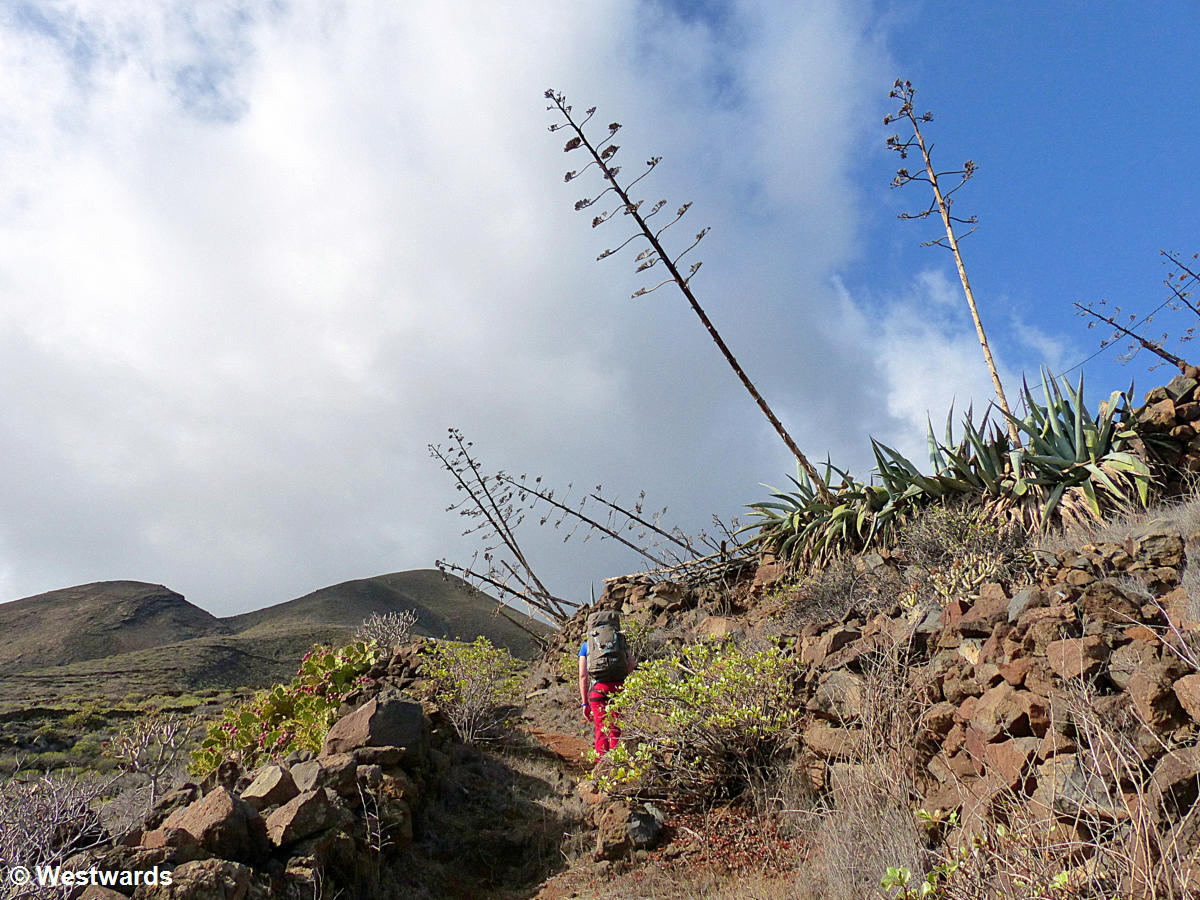
We have started our long distance hike on El Hierro on the coast in La Caleta, not far from the harbour where the ferry arrives from Teneriffe. The long distance trail GR 131 crosses the whole island. First we climb up into the highland between cacti, huge agaves and dry stone walls.
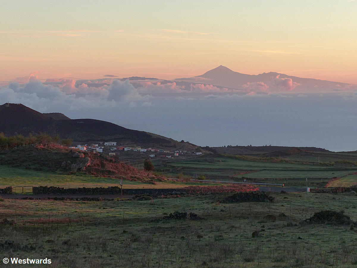
Up on the mountains, clouds are closing in, and the higher we get we see them move quickly over the slopes. Near Tinor we meet an elderly German hiker who tells us she has been on El Hierro for a few days and so far was lucky with the weather. Only drifting clouds – no rain and fog. That evening above the high plateau, the Meseta de Nisdafe, fog comes with the darkness, but it is not cold. And by sunrise the air is clear again and we have a splendid view of Spain’s highest mountain Mt Teide on Tenerife. We remember our climb of Mt Teide very fondly.
Day 2: Behind San Andres to Faro de Orchilla
28,2 km, 570 m up, 1640 m down

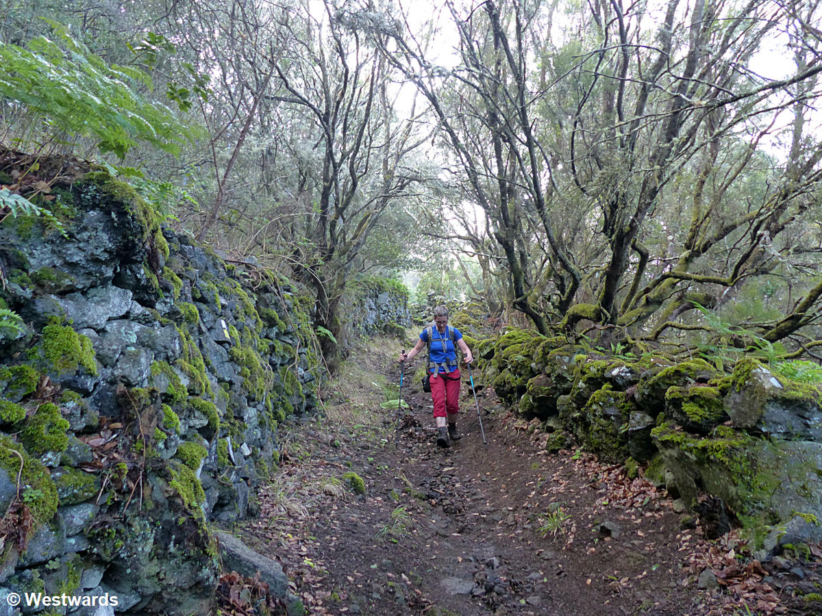
The GR 131 trail is doubling as a pilgrimage route now and therefore well-maintained. But above 1300 m we have run out of cacti and meadows and enter the pine forest. On the top of Mt Malpaso, at 1501 m El Hierro’s highest peak, we have an uninspiring break beneath the tall antenna tower. And then we follow the mountain ridge on the dry South side, with volcanic desert and occasional spill-overs of rain and cloud forest. The clouds always linger on the steep northern side of the ridge (actually the remains of an enormous landslide a few thousand years ago).

The pilgrimage path ends at the hermitage church Virgen de los Reyes. This is the official start of the island’s grand pilgrimage that takes place only every four years. After a brief stop we load up on water and continue hiking to the Orchilla lighthouse down at the western coast. More cacti, strange-looking spurge, and volcanic rocks.

Day 3: Faro de Orchilla to Sabinosa
14,3 km, 900 m up, 790 m down
We spend the night near the lighthouse on soft volcanic ash between sparse shrubs and in the morning go to visit the classical ferro meridian as set by Ptolemy in the 2nd century AD: the westernmost point of the known world back then. It is not quite at the coast, however – Ptolemy himself never travelled here and defined his zero meridian for the mapping of the world at 20° west of Paris. It was used by cartographers until the late 19th century when the Greenwich meridian became standard.
The Zero line
A very important abstract concept for centuries – the “zero” line on all maps that earlier travellers and seafarers used – one might think, but there’s not much to see except a nice view of the nearby Atlantic coast. A lame memorial has been built to mark the “westernmost point of Spain”, but you have to bring your knowledge about the historical significance from home.
From the coast we hike up in ferocious heat and with only a litre of water remaining between the two of us. 5 sips every 200 meters of height, we decree. At one of those stops, we notice a beautiful storm out above the ocean: All shades of black and blue, flirring with some sunlight. A few minutes later we notice the clouds come up after us. 12:15. “How long do you think it will take to catch up with us?” “Not long, maybe 10 minutes?” And at 12:18, the first raindrops hit. At 12:22 we continue our hike clad in full raingear. By the time we walk away from our break at the hermitage church, the weather has improved again and our hike through the still wet and glistening cloud forest on the northern side of the ridge, toward the cute village of Sabinosa is splendid.
Day 4: Sabinosa to Virgen de los Reyes
21,7 km, 970 m up, 500 m down
The next day brings us in a loop along the north-western coast to two of the most spectacular landscapes of the island: The basaltic lava cliffs at Punta La Dehesa and Veronal are breath-taking, with numerous natural arches that create whole choreographies of immense waves.

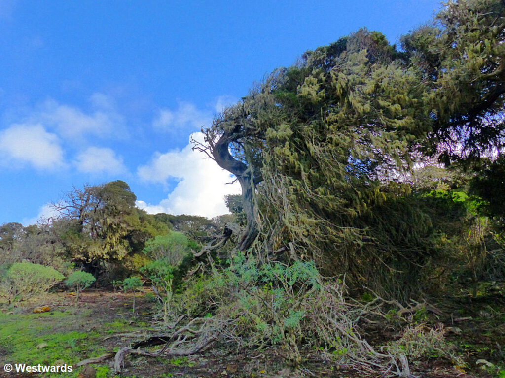
600 m higher we pass not only good viewpoints but also the weather-beaten juniper trees of El Sabinar, growing horizontally in the strong westerly winds. At the end of the day we reach the church of the Virgen de los Reyes for the third time, fill up our water bottles at the well and look for a good camp site nearby.
Day 5: Virgen de los Reyes to El Pinar
20,5 km, 770 m up, 630 m down
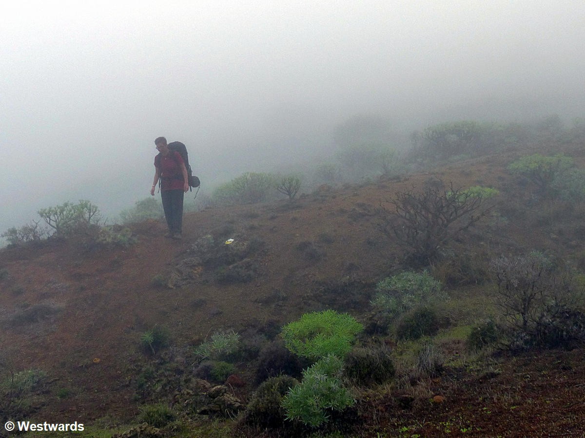
So far, we have been blessed with more or less fine and sunny weather while hiking on El Hierro, but on the fourth day the weather finally changes. Starting out from the hermitage church in a grey and cool day, we hike above the Southern coast on the El Julan trail on the edge of a dense pine forest. When the trail winds down into rocky terrain only visited by occasional sheep and rabbits, the rain starts. The fog is often too dense to see next trail marker on the stones, and hiking with luggage on the slippery rocks becomes very slow. To our disappointment, the bar at the El Julan visitor centre is closed – but the staffer at the ticket desk takes pity on us and makes us coffee before we continue (on the road) to El Pinar.
Day 6: El Pinar to Isora, 8,8 km
390 m up, 350 m down
We skip our planned excursion down to the coast and up again on steep traditional stone-paved trails as it is still heavily raining the next day. Instead we have a late start and an easy day walk amid gardens and almond plantations over to the village of Isora, where we have rented a cottage for one night.
Day 7 Isora to the ferry harbour Puerto de la Estaca
8,8 km, 170 m up, 1030 m down
From Isora it is just another half-day’s walk to the harbour, where we catch the ferry back to the touristy island of Tenerife.
If you are looking for a hike through very diverse nature with few other hikers, El Hierro might be a destination for you. We have GPS tracks of our hike (email us for details) and the tourist offices on El Hierro hand out a free hiking map that we used for planning. We had also brought the German “Rother” hiking guide, which was only partially useful, as it covered mainly day hikes from parking areas (but with GPS tracks for all hikes).
Would you like to go hiking on El Hierro? Or did you hike on any other of the Canary Islands – let us know! We also did some hiking on Gran Canaria, one of the bigger Canary Islands, where you can combine your hiking with some sightseeing.
*** Our hiking tour was self-organised, paid for by ourselves, and not sponsored in any way ***
Never miss a new post! Get notifications about new posts straight into your inbox!
Interested in hiking on El Hierro? Then pin this post for later!


A great post on hiking the El Hierro mountains. It’s commendable how you climbed the mountains with few sips of water,only a passionate traveler is capable of doing it. And the basaltic lava cliffs at Punta la Dehesa with splashes of waves carving the arches into rock formations is amazing!
Thank you so much for sharing!
We visited 3 of the Canary Islands but never heard about El Hierro. Although I now know we could have visited from Tenerife. A multi day hike is probably beyond us but we might want to try a day hike if possible. Even if we would miss the great early morning and sunset views. It sounds like a tough hike over many days but the views sure look great. At least when it was not raining or in heavy fog. Good that you had a cottage booked to give you break from the weather. I will check out your hike on Gran Canaria for hiking with sightseeing.
Dear Linda, yes, El Hierro is the smallest and least known of the Canary Islands. The tourist infrastructure is not geared towards groups and there are less hotels and restaurants than on the other islands. But that makes it quite charming.
This sounds like an adventure. I would love to visit this island with just 10,000 inhabitants. Living in India, we hardly see a quiet places, except for the harsh mountains. The terrain in your pictures looks emerald, rocks wrapped in waves, I am sure it’s quite an unforgettable hike.
The trail in the beginning reminded me of Big Bend National Park in Texas. The vegetation started with cacti and huge agaves then turned to pine and greens. Your 7 day hiking trip is surely amazing. The views are spectacular, especially the coast one.
Dear Umiko, I can imagine that Texas has a similar vegetation, especially with the cacti and the agaves.
Wow hiking for one week seems like such an amazing trip. I have not been on one week self organised hike ever, the max I have done is 4 days. I have never heard of El Hierro before even though Canary Islands are on my list. I am surely adding this hiking trail on my bucket list. But being a solo traveler, I am not sure if I can do this on my own, especially because it has so less people.
Dear Raksha, hiking on your own would be possible, but you would have to carry some food. The Canary Islands are a very safe destination for solo travelling women.
Love that you hiked and camped as too many people opt for luxury hotel pampering and miss out on the real experience of connecting with nature. You covered a lot of ground and saw some amazing scenery!!
Some amazing photographs there. Looks like you had some slightly mixed weather on your week-long hike, but mostly favourable. Love the second photo of the mountains!
You must be really fit to do these such long hikes and over a period of a week. But just experiencing it through you is itself so refreshing. Such a beautiful journey with blue skies.The basaltic lava cliffs at Punta La Dehesa and Veronal are certainly breath-taking. The Canary Islands is a must go destination whenever we are around there.
Dear Suhashish Roy, we have been on Gran Canaria, Tenerife, Fuerteventura and El Hierro so far. All of the islands were fantastic and quite different. With El Hierro being the least touristy.
It’s wonderful that the weather cooperated with you on this adventure on the first few days and then gave you a different feel in the last leg. Nature can be so diverse and surprising in different settings. It’s so reflective of how life is.
Yes, but it always sucks when you get drenched while hiking. El Hierro is beautiful though and the rain did not change this.
Hi guys,
I just stumbled across this page while doing research into trekking in the Canaries (planned for late Dec early Jan). I assume you used this trail: https://www.wikiloc.com/hiking-trails/gr-131-el-hierro-12410107 which is listed as the GR131.
My main question is regarding water – did you make any notes of the resupply points? I assume you guys did not wildcamp and stayed in hotels, therefore can I assume that each day the places you marked as the beginning/end of the day have water?
Any ideas welcome!
Ross
Dear Ross, actually we did wildcamp half of the week. The GR 131 is only a short hike (1.5 day max) on El Hierro. We included it in a longer one week hike. Water is difficult on the hike in winter as many official water sources are closed. There is a reliable fountain at the hermitage church Virgen de los Reyes. We passed that point several times on our hike and stocked up with water there. We used a map for the planning, but I can send you our GPS tracks.
Hi Natascha,
You’re GPX trax would be welcome! You should be able to see my email in the metadata of this comment. (I’ve figured out the 131 goes around all of the islands?)
In terms of packing (for Dec/Jan) it does seem I should pack for 3 seasons? My sleeping bag goes down to 0 (comfort) and -7 at a push, so I figure that should be okay. Otherwise I’d want to go as light as possible. Where there any things you really wish you’d taken and/or left behind?
So far was thinking of doing the 131 on Tenerfe and the 132 (?) on La Gomera. Be interested to know any packing tips you might have. If I’m wild camping, I expect I’ll have capactiy for 3-4lt, a stove (is camping gaz easily come by?), plus a solar panel for charging gadgets. Would waterproof trousers and down jacket be overkilll?
Well lots of questions!
Many thanks in advance…
Hi, great photos and beautiful hike. We are planning to go there in November, currently planning a multi-day hike. Could you share the GPX file with us? Thanks a lot!
Hello,
What a beautiful hike you made through El Hierro. Is it possible to share your GPS tracks with me? Thank you in advance!
Elise
Dear Elise, we are travelling right now, but we will be back home soon. I will send them within the next few days! Great that you liked our post!
Hi Isa and Natasha,
Thank you for sharing your adventure in El Hierro; it sounds a wonderful trip. I’m Spanish myself, but I live in Scotland, I teach at the School of Adventure Studies in Fort William. I’ve been thinking about doing a multi-day walk in El Hierro (from the end of Dec into January), as the idea of the ‘Zero Line’ having represented the end of the known world in the past truly captures my imagination – I teach Anthropology of Place.
I wonder if you could share your GPX or KML tracks, which would be really helpful. I presume that you wild camped, any tips or advice on that?
Many thanks!
Jose
Dear Jose, we wild camped most days (two days we had really bad weather and asked around for a cheap accomodation). Wild camping is officially prohibited on the Canary Islands but you should always be able to find a secluded spot. Water was a probelm though. There are some fountains but they are turned off during the colder months. Carry a lot and refill whenever possible. We sometimes had to ask people in their garden or in shops for water. I will send you the gpx tracks today.